About
Other
Summits on the air
Adventures in ham radioMy Sota Philosophy: Despite what the rules say, I will not activate a summit unless I hike it. I must:
- Be on the true summit or within a reasonable distance of it. I figure 20 vertical ft is reasonable for just about any summit. The only case I can think of around here is MAYBE broken top where the last 50' is a technical climb. But then, CM-003 is a REAL technical climb that I will likely never complete.
- Must not drive to the summit. If the summit is driveable, I must hike the summit through some route other than the road. (Good example is CE-009, where there is a trailhead in the caldera that hikes up 5 miles to the viewpoint. A road follows a seperate route there). Driving is cheating and violates the spirit of SOTA.
- Should be QRP, 5-10W maximum.
June 21st, 2020: Stams Mtn, W7O/CE-055
 |
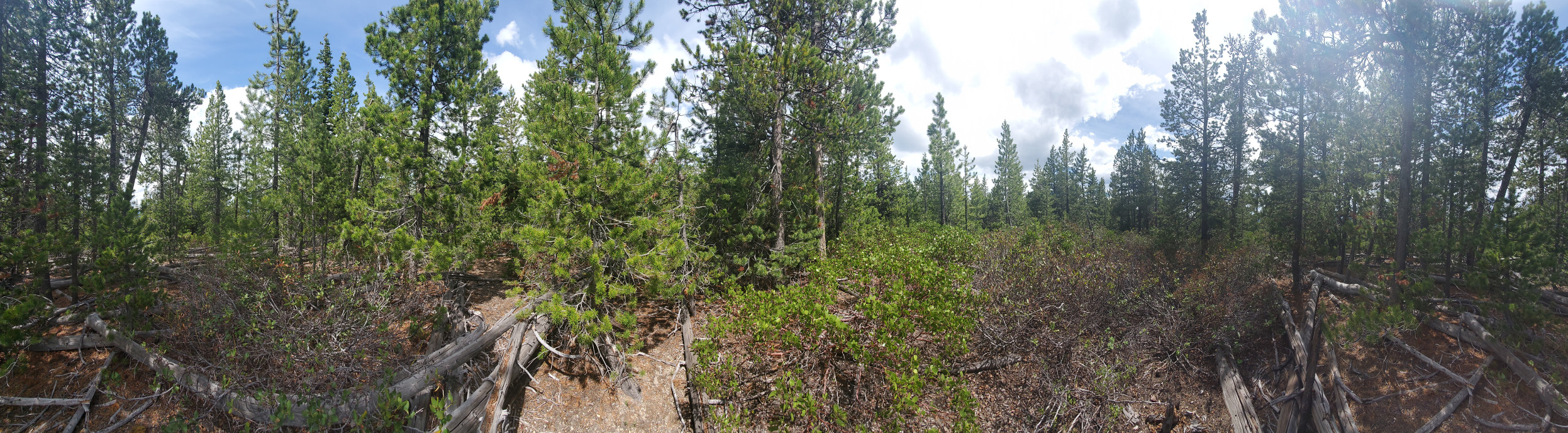
| 6/21/2020: W7O/CE-055 Stams Mtn |
Stams Mountain is a kind of 6-pt hill on the northern edge of the Freemont-Winema national forest. Approx 1hr 15min drive from Bend, use Deschutes MVUM #9 and Freemont-Winema MVUM #2 with Avenza maps to get to the 'trailhead'. There is one road that goes right by the base of the mountain, forest road 2415. Driving from highway 97, take Hwy 31 east for 15 miles. At the 15 mile marker point, you will see a turn-off from the road for 2415 across from a USFS fire warning sign. Take this road south for some 8 miles of washbordy gravel road. The worst washboards are past the logging camp. The turnoff is at 43°22'17.03"N 121°27'4.06"W. At this point, you have a decision to make. Do you value your vehicle? Do you have high ground clearance? Are you a tree hugger? You can park at this junction, or continue up the road maybe a quarter mile until you run into trees that are too big to drive over. But to even get to that point, you'll be scraping paint and killing saplings. Park and go hiking. Take your GPS and just straight line navigate to the summit.
 |
| Stams Mtn Summit view |
As stated earlier, you make your own trail. It's fun, enjoy it. I suggest a hat and sunglasses, durable pants and shirt, because you WILL get hit by branches. Mid-june I was getting hit by mosquitos, and the pollen was in full season - my backpack came out yellow.
However note, there are 3 'summits' on Stams mtn, and the Freemont-Winema MVUM has the summit in the wrong spot. The activation zone for Stams is nearly a half mile wide going East-west, and covers all 3 summits. The three summits are within 10 vertical feet of each other, and don't dip below 50' between them.
There isn't much of a view at the NW summit. You get a few views of Diamond Peak heading back if you find a good clearing. The SW 'true' summit may do better for views. I was able to send text spots from the summit. 14 contacts (including 2 s2s) in half an hour and I was happy. The new battery pack worked gangbusters. Really, all I need to do is improve my logging with a reasonable portable computer of some kinda (that can send serial commands to the KX3 hopefully), and I'll be golden.
May 23, 2020: Horse Ridge, W7O/CE-176
 |
| 5/23/2020: W7O/CE-176 Horse Ridge |
The hike itself was a pretty straight forward cross-country trek, about 1.5 miles each way and about 850' elevation gain. There are a few barbed wire fences to cross, some down and historic, some more modern and maintained. None presented a real obstical though. Use of Avenza maps and the Horse Ridge Recreation map provided by the BLM is highly encouraged. The northbound OHV trail and BLM roads technically go through private property to my understanding, though the BLM might have right of way. The road going up into golden basin is technically off-limits to vehicles, though while I was at the summit, I still saw a motorcyclist. Otherwise, not a single person on the summit... Just the way I like it.
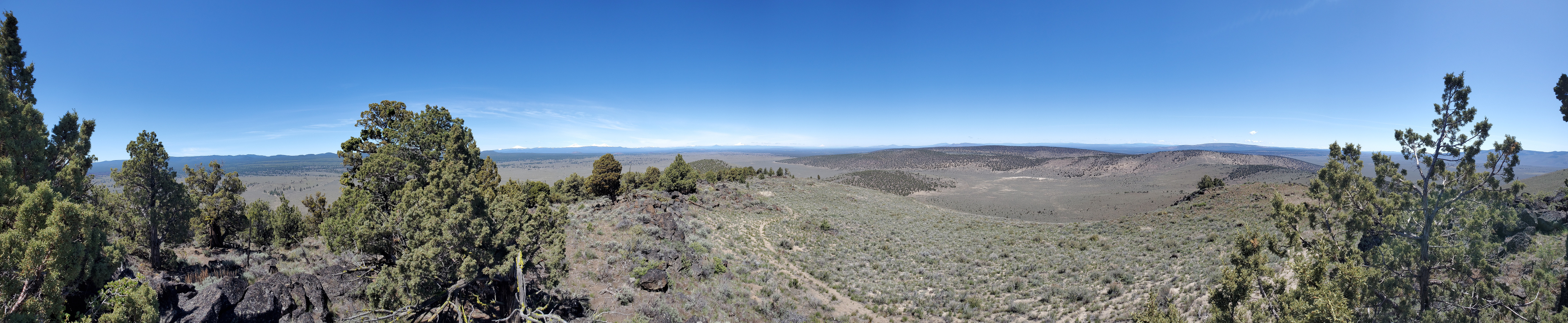 |
| Horse Ridge Summit view |
My trip up was basically a straight north ascent and then following the ridgeline WNW to the summit. There are a few false summits, take a GPS (or avenza maps) and you'll get there.
This weekend was near perfect weather. Not too cold, not too hot, a slight breeze to take the edge off the sweat of hiking after 2 months in quarantine.
My setup is a KX3 with a homemade 20m 2-radial vertical on a 25' fishing pole/mast. I will post a youtube video from the summit on this front, search my callsign on youtube, and you'll find my channel for an upload on that probably sometime next week.
In the end, 23 contacts, 1 summit-to-summit, and a great first time activation for me. I'm happy with how it went, and the worst thing I forgot was my hiking boots (so I just hiked in shoes instead, no big deal). I thank all those who tried to contact me, put up with newb CW skills, I will happily send QSL cards to all those who suffered through my lack of comprehension. Nearly all signals were strong and 5x9, (x variable by strength, my noise floor was near zero), so it wasn'propogation that made me ask for repeats, it was operator error :)
I got in the mail a new battery pack for my KX3 today, that I hope will be more consistent than using AA NiMH batteries in the KX3, but failing that, a single set of NiMH batteries did just fine.
Activations being considered
Current activations that I want to do. Not in specific order. Unless specified, all are W7O Oregon region.- (May 30 2020) CE-055 Stams Mtn
- (June 6, 2020 - Double?!) CM-017 Hamner Butte
- (June 6, 2020) CM-042 Ringo Butte
- (June 2020) CE-058 Pine Mountain
- (June 2020) CE-068 Pine Bench
- CE-056 Antelope
- CM-022 Maklaks (winter)
- CM-046 Royce (winter)
- CM-032 Odell (Winter)
- CM-093 Ranger
- CM-016 Devils Hill
- CM-027 Cultus
- CM-012 The Husband
- CM-062 South Pyramid
- CM-053 Echo Mountain
- CM-009 Maiden Peak (Winter!)
- CM-023 Redtop
- CM-079 Two butte
- CM-041 Proxy Point
- CM-036 Substitute point
- CE-053 China Hat
- CE-260 6314
- CE-039 Lookout Mountain
- CE-184 Valpy Mtn
- CE-182 Cadle Butte
- CE-009 Paulina (Winter)
- CE-014 North Paulina
- CE-013 Slide Mountain
- CE-096 Indian Butte
- CE-103 Willow Butte
- CE-032 Odell Butte
- CE-066 Marmot Butte
- CM-047/49 Packsaddle & Little Roundtop
- CM-124 6242
- CM-040 Horse
- CM-030 Koosah
- CM-020 The wife
- CM-032 Millican Crater
- CM-033 Black Butte
- CM-039 Maxwell Butte
- CM-058 Crescent Mtn
- CM-082 Wildcat
- WV-003 Bachelor
- WV-005 Coffin
- CM-044 Katsuk Butte
- CM-043 Cupit Mary Mountain
- CE-085 Pothole Butte
- CE-188 Lava Butte (Winter)